
Tools for public service journalism: Q&A with Casey Miller

Interview by Rebecca Greenway, University of Missouri journalism student

For Innovation in Focus this month. we experimented with public service tools for journalism. We spoke with Los Angeles Times’ Casey Miller, a data journalist who helps the Times track earthquakes, wildfires, and other disasters through automated tools like Quakebot and Fire Map.
Greenway: Could you begin by talking about how you first got involved with data automation and what some of your initial goals were?
Miller: When I started at the LA Times a year ago, the main directive was to revitalize our QuakeSpot application. It involved a lot of rewriting and bringing it up to speed, since it had been created in 2012, as well as developing a wildfire map.
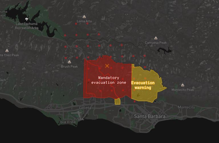
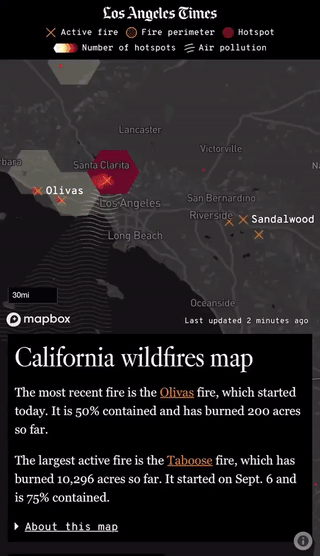
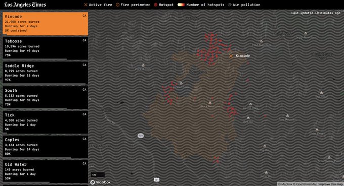
Quakebot coverage is pretty important for us as a paper and is a regular profit-driver as well. However, whether or not it converted more subscribers, we wanted to add features and increase our coverage since people were really interested in it. As for the Fire Map, we didn’t have automated fire coverage, so reporting always included a lot of scrambling. Our new Fire Map pools from about eight different data sources, and it not only populates the map but saves the data for other custom visualizations we can produce later. Features we’ve added to the automated tools have eliminated many hours for the graphics team, which was nice as well.
Greenway: Have you worked with crowd-sourced content like citizen videos and commentary?
Miller: We didn’t, but that’s not to say that we never will. There are two main reasons that we didn’t do that. One, this is just getting off the ground. Our disaster coverage was already strong, and we continued to develop features based on reporting needs at the time. Secondly, it would just require a lot more oversight. We’d have to review submissions somehow to verify them, but that’s not to say we won’t revisit the idea later. I know that there is something appealing about being able to have users submit fire photos and comments, but we aren’t set up for that yet to be automated.
Greenway: How did you go about learning these new tools and staying up-to-date?
Miller: It’s complicated! I did a lot of mapping this year with Mapbox. While I’m by no means an expert, I was familiar with it at least. When you are familiar with a tool — even if you don’t know how to do something — you can think, “Well, I know three of the five things needed for this. I bet I could figure out the other two.” Also, if you can use one tool for the whole application, it’s great. I often have to mash systems together, but it is nice if you can use one application such as Mapbox to do all five of those things.
Keeping up with the new stuff is hard, though. I don’t have an exact answer, but it helps when your whole team is moving forward. You also have to have time to devote to it. It’s great if your boss can give you two weeks instead of one when you are learning something new. However, not all newsrooms have that flexibility. I do have a hard time learning new things without a hugely compelling reason to do it, so there’s something to be said for having a very specific set of things that need to get done, then figuring out how to do it right.
Greenway: What are some of the lessons you learned working on these projects over the last year?
Miller: People here really want to know about earthquakes and fires, and I feel like it really is providing an important service. To that point, when I was reworking the Fire App with a new data source, I found that we had access to some additional data. Since we weren’t in a huge time crunch, I felt like I could take a couple of weeks to try to set up a service that automatically makes maps out of the new perimeters data. I thought it would benefit our quake coverage, but it ended up being great. People love it, and it’s been even better than I thought it would be. It showed me that these small improvements can make a big difference.
Greenway: So what’s next? Are there new tools you are hoping to learn or new projects on the horizon?
Miller: With the Quakebot major overhaul done, one of the things I want to do is see if there is any other data that is worth collecting that could be valuable to add as map features. I would also like to work on quick-turn stories and work with interested reporters on visual stories with the data.
We’ll probably also do another version of Fire Map. There’s so much more that we could do with some improvements, but I don’t know exactly yet. We have a group of graphic and data journalists who do a lot of our disaster coverage. We’ll put our heads together and see what we think would be most valuable to pursue this year.
Editors note: This interview has been edited for length and clarity.